
In landscaping architecture, you will often find two main challenges which are getting vegetation and creating a terrain. For vegetation, you can use one of the several libraries we share with our readers, but for terrain generation, you will have to choose among several alternatives.
The vegetation layout will probably be a direct outcome of your project, which gives the artist complete freedom to create. In the other hand, a terrain may require you to reproduce a real site in detail.
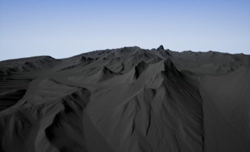
A handy Python script, not related to Blender, may assist you with terrain modeling.
The purpose of that script is to create height maps from images (IMG, ArcGrid or GeoTIFF format supported). As a result, you will get a 4096 x 4096 map (PNG) to reproduce the terrain.
Even with a clear objective of creating height maps for game developers, architectural visualization artists might also make use of such tool for landscape architecture.
You just have to find a database with elevation data from the region of your project.
If you follow the link to the script page, you will also find a full description of how to use it.
And for those of you still trying to learn architectural modeling, take a look in our online training:
- Course about architectural modeling with Blender
- Course about parametric modeling for architecture with Blender
